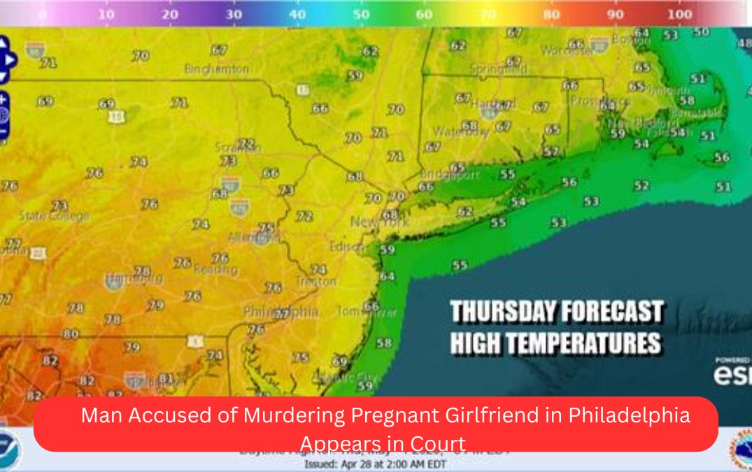
Strong cold fronts moving through the Northeast are raising the risk of severe thunderstorms and heavy rain this Friday and Saturday. Areas from New York City through Pennsylvania and New Jersey could experience isolated severe storms amid warm, humid conditions.
What Happened
Two weather systems will impact the Northeast this weekend. The first cold front arrives Friday, bringing warm temperatures and a chance of isolated severe thunderstorms, especially from New York City south and east.
A second, stronger cold front moves through Saturday morning, primarily affecting Eastern Pennsylvania through Southern New England, with a higher chance of severe weather and scattered thunderstorms.
Key Details
- Friday Weather:
- Warm and humid with highs in the upper 70s (°F) in southern New Jersey and Pennsylvania.
- Showers and thunderstorms developing later in the afternoon and evening.
- Isolated severe thunderstorms possible, mainly south and east of New York City.
- Saturday Weather:
- Second cold front passes, with showers and thunderstorms possible in the morning.
- Higher risk of severe storms, especially in Eastern Pennsylvania, Southern New England, and Upstate New York.
- The Storm Prediction Center indicates a “slight risk” (15% chance) of severe weather and a marginal risk further north.
- Temperatures mostly in the 70s to near 80 degrees.
- Front expected to clear the coast by midday, leading to improving conditions in the afternoon.
- Flash Flooding Risk:
- Ground is saturated from previous rains, increasing flash flooding potential with heavy downpours.
Reactions and Statements
The Storm Prediction Center has issued a slight risk alert for severe thunderstorms this weekend, advising residents to stay alert for possible heavy rain, gusty winds, and isolated severe storms.
Local authorities recommend preparedness for sudden weather changes, especially in flood-prone areas.
Investigation or What’s Next
Meteorologists will continue monitoring the progression of these cold fronts and storm systems.
Weather models indicate a transition to cooler, more stable weather early next week, but late-week forecast uncertainty remains high with potential for another storm bringing rain and wind toward the Memorial Day holiday weekend.
FAQs
Q1: Which areas are most at risk for severe thunderstorms?
A1: Southern New Jersey, southeastern Pennsylvania, and New York City south and east are most at risk Friday. Saturday’s higher risk extends to Eastern Pennsylvania, Southern New England, and Upstate New York.
Q2: What time will storms likely occur?
A2: On Friday, storms are expected to develop late afternoon through evening. On Saturday, showers and storms will likely occur in the morning before conditions improve midday.
Q3: Is there a risk of flooding?
A3: Yes. The ground is already saturated, so heavy rain could lead to localized flash flooding, especially in low-lying or urban areas.
Q4: What happens after the storms?
A4: Cooler and drier conditions are expected Sunday through midweek, with highs in the 60s and 70s, but another potential storm system may impact the region late in the week.
Q5: How should residents prepare?
A5: Stay updated on local weather alerts, avoid flood-prone areas during heavy rain, and prepare for sudden changes in weather conditions.
Summary / Final Takeaway
Strong cold fronts will bring a multi-day threat of showers, thunderstorms, and isolated severe weather to Pennsylvania, New York, and New Jersey this weekend.
Heavy rain may cause flash flooding due to saturated grounds. Following the storm passage, expect cooler weather early next week, but watch for late-week storms ahead of Memorial Day. Staying informed and prepared is key to weathering these conditions safely.